
GET · 1 credit
/greens/getSlopeImage
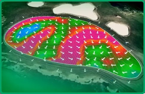
Green slope render, including image URL. 900×1620. Query holeId and imageSizeType = Portrait | Square.
3D green slope data
Elevate your app’s putting experience with high-resolution 3D green slope maps. Image endpoints return a hosted imageUrl plus geometry to overlay a pin or ball. Geohash is the live lie-elevation layer — not coming soon. The test pack is Tester $49/mo · 100 credits.
Green slope and elevation come from the same 20-year proprietary course dataset. Proprietary golf course data to serve the industry. Daily course updates around the world since 2007. Apps usually pair this with a course scorecard and GPS on the Golf Intelligence API.

GET · 1 credit
Green slope render, including image URL. 900×1620. Query holeId and imageSizeType = Portrait | Square.
GET · 1 credit
Green elevation render. Same size and DTO as slope. The topography layer for ball physics and AI.
GET · ask us
Live lie elevation. Geohash cells with GPS altitude so you can compute uphill / downhill / sidehill. US and UK are strongest — send course names and we will check.
Cost: 1 credit per rendered slope or elevation image — billed on the same API pricing as a full course. Cache image files up to one year per user. Green maps expire daily if you re-fetch.
Next step
Tester is $49/mo for 100 credits to download courses, green slope, and elevation. Email data@golfintelligence.com for Starter or partner volume. Console login is your email plus a verification code.
Start Tester — $49/mo. Credits are added in the console after payment. Starter is $399/month for 10,000 credits for apps.